
127 acres in the proposed area
That's nearly every open acre left in Orchard Heights — fields, tree stands and waterways that can never be restored once grading begins.
A proposed development across 127 acres would bring up to 500 apartments, 320 houses, 110 duplexes, major road reconstruction, and a possible exchange involving public land. The consultant lowered the headline count. The scale is still wrong for Orchard Heights.
We’re organizing now to protect Orchard Heights’ wildlife habitat, wetlands and riparian corridors, neighborhood safety, and the public services this scale of growth would depend on.
The Scale Orchard Heights Is Being Asked to Absorb
That's nearly every open acre left in Orchard Heights — fields, tree stands and waterways that can never be restored once grading begins.
Plan 4 says 300. The zoning allows 500. The number residents should plan for is the one the consultant's zoning would legally permit — not the one in the sales pitch.
The consultant presents 730 homes as the plan. But the zoning they're requesting could legally support 930. The lower number gets the approval. The higher number gets built.
Three hundred twenty houses on top of hundreds of apartments means well over a thousand new households competing for the same narrow roads and limited services.
The consultant doubled the duplex count from 56 to 110 between plans. If density keeps climbing with each revision, what number will residents actually get?
Nine hundred thirty homes on 127 acres would permanently transform Orchard Heights from a quiet residential neighborhood into a dense urban district — with no proof the infrastructure can handle it.
What residents are protecting
Residents aren’t asking Salem to ignore the need for housing. We’re asking the City to prove that this scale of construction won’t sacrifice wildlife habitat, wetland and riparian function, neighborhood safety, or essential public services.
The current proposed plans don’t yet provide the field studies, capacity analysis or binding protections needed to answer those concerns.
What species use the fields, tree stands, waterways and riparian corridors—and how would grading, roads, lighting and habitat fragmentation affect them?
Where are jurisdictional wetlands, seasonal drainage areas and stream buffers? Independent delineation should come before a buildable-acreage claim.
Which trees would be removed, what habitat would be lost, and what protections would remain binding after future ownership changes?
Can Orchard Heights Road, Grice Hill Road, Islander Avenue and nearby streets safely absorb every phase, including construction traffic?
What upgrades are required, who pays for them, and can existing systems support each phase without shifting costs or risk to residents?
What school capacity, safe routes, fire flow and emergency-response resources would be required before new homes are occupied?
Independent environmental work needed
Residents need wetland delineation, riparian-buffer mapping, wildlife and habitat surveys, significant-tree inventories, drainage-basin analysis, and a clear explanation of effects on Dahlia Swale and Archer Creek.
Capacity before construction
Can existing streets handle every phase, construction traffic and emergency access without shifting harm onto nearby neighborhoods?
What upgrades are required, what do they cost, and who pays before new demand comes online?
Which schools would serve the proposal, what capacity exists, and how would students get there safely?
Do fire flow, station coverage and road design support reliable response times at full buildout?
What the buildout would change
The plans describe a phased subdivision, zoning changes, extensive road and utility work, tree removal and preservation, stormwater facilities, mixed-use development, and a possible exchange involving City-owned land.
Development would occur in phases, reportedly beginning near Islander Avenue.
Without finalized phases, the consultant can change what gets built where and when — and residents have no enforceable schedule to hold them to.
The current proposed plans describe a master-plan application package.
No complete application has been accepted by the City. Until one is filed, there are no binding conditions, no public comment period and no enforceable commitments.
Much of the southern RA-zoned land would change to residential zoning; MU-II would be reorganized.
Rezoning is the point of no return. No final boundaries or approval requests have been filed — but once they are, the farmland zoning that protects this land today could be erased.
Plan 4 presents 300 apartments at minimum density, but the requested zoning allows up to 500 on the same land. The consultant now frames these as possible ‘senior housing.’
Calling it ‘senior housing’ doesn’t change the zoning, the density or the infrastructure load. The consultant is requesting the same MU-II designation that allows 25 units per acre — with no binding commitment to build for seniors.
Plan 4 shows 320 single-family houses on lots the consultant describes as roughly 5,000 to 6,000 square feet.
The consultant dropped the house count from 342 to 320 but increased duplexes from 56 to 110. The total footprint barely changed — it just shifted to higher density. And lot sizes still aren’t binding.
The duplex count nearly doubled from 56 to 110 between Plan 3 and Plan 4. Each pair occupies a separate lot described as owner-occupied with garages.
Doubling the duplex count from 56 to 110 adds 54 more households to roads and utilities that haven’t been studied for the original number. The consultant’s promise of owner-occupied units with garages is marketing, not a legal commitment.
The consultant’s revised road plan reroutes collector traffic through Islander Avenue to Titan Drive, adds a new collector to 32nd Avenue, and keeps Orchard Heights Road in place. Stantec Engineering is preparing grading plans.
Swapping 35th Avenue for Islander Avenue as a collector doesn’t solve the fundamental problem: no traffic study has been completed. Residents are being asked to accept a road network drawn by the consultant’s team, for the consultant’s benefit, without independent verification.
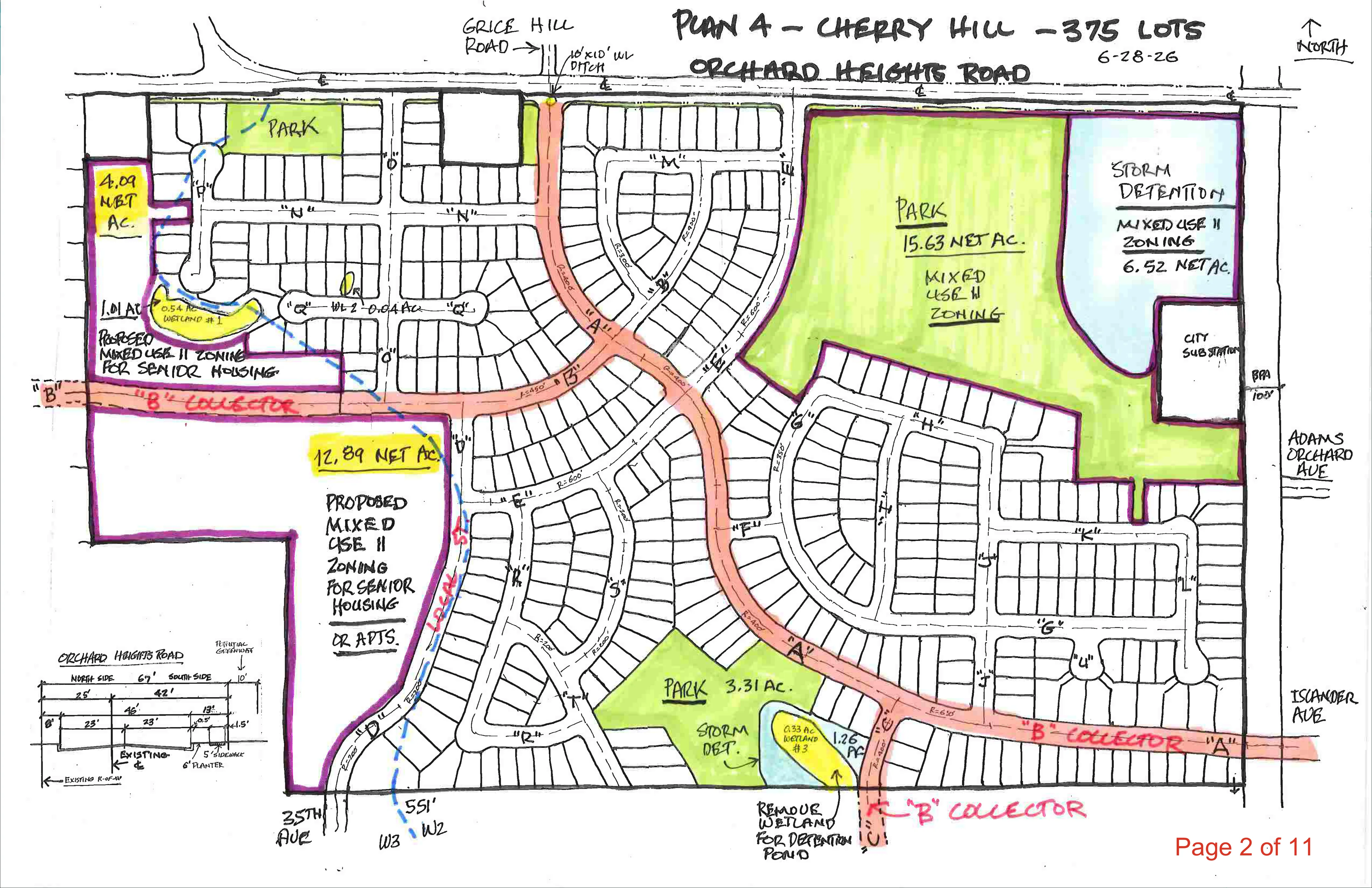
The consultant labels 15.63 acres as a public park and identifies significant trees on the topo survey. But the ‘private park’ only exists if the City refuses the land trade — meaning the consultant controls whether residents get public or private green space.
A 15-acre park sounds generous until you realize it’s contingent on a land trade the public hasn’t approved. If the trade goes through, residents could end up with less. And ‘significant trees marked’ isn’t the same as ‘significant trees protected.’
The revised plan allocates 6.52 acres for stormwater but also proposes removing an existing wetland to build a detention pond — trading a natural water system for an engineered one.
The consultant proposes removing a wetland to build a detention pond. Destroying a natural drainage system to engineer a replacement raises serious environmental questions — and no independent review has evaluated whether the trade-off is sound.
The current proposed plans mention a possible small commercial center near the northeast corner.
A ‘possible commercial center’ could mean anything from a small café to a strip mall with delivery trucks and late-night hours. No plan, no traffic estimate and no noise study has been provided.
A possible exchange involving City property north of Orchard Heights Road is described.
Residents own this land through the City. Trading it away without transparent valuations, public hearings and documented terms would be an accountability failure.
The development could add hundreds of school-age children and nearly double emergency call volume in the area.
No school-capacity study has been produced, and no agreement exists with the district on funding, siting or timing for new facilities. Families could arrive before classrooms exist.
The consultant now frames the MU-II apartment zones as potential 'senior housing' — a label that appeared for the first time in the August 2026 revision.
'Senior housing' isn't a zoning category in Salem. It's a label the consultant chose. MU-II zoning allows apartments of any kind, for any age group, at any density up to 25 units per acre. The label could disappear the moment the zoning is approved.
A project of this scale could mean years of heavy equipment, truck traffic, dust, noise, and road closures through a neighborhood with one main road in and out.
No phasing schedule, haul-route plan, or construction-hours commitment has been provided. Residents deserve to know how long disruption would last and what protections would be in place before anything is approved.
Who to contact
Residents can direct questions to Ward 8’s elected representative and the project’s planning consultant. Ask about the proposal’s scale, traffic, infrastructure, wetlands, wildlife, public land and review schedule.
Ward 8 City Councilor
City of Salem
Ward 8’s elected representative can press for complete studies, a transparent review process and clear answers about whether this proposal fits West Salem.

Project planning consultant
Planning & Land Design, LLC
The planning consultant identified in the project materials should be able to address plan details, unit assumptions, road concepts, environmental work and the proposed land exchange.
A Scale the Neighborhood Can't Support
The consultant’s revised Plan 4 presents 730 homes as the new target — 320 houses, 110 duplexes and 300 apartments at 15 units per acre. But the zoning they’re requesting allows up to 25 units per acre, which would push the apartment count to 500 and the total to 930. The consultant lowered the headline number from 898 to 730, but the zoning hasn’t changed. Nothing prevents the density from climbing right back up after approval. And residents’ objection is more fundamental: Orchard Heights cannot support even the reduced figure, and the neighborhood opposes any number of apartments on this land.
The consultant's density range
Consultant's Plan 4 figure
300at 15 units/ac
Consultant's stated maximum
500at 25 units/ac
Plan 4 stated total
The consultant's own narrative states a maximum density of 25 units per acre. At that density, the apartment areas produce 500 units — not 300 — pushing the total to 930. The zoning doesn't lock in the lower number.
Resident position
Whether it's 300 apartments or 500, the result is the same: a neighborhood that was never designed for this density gets permanently transformed. Residents oppose apartments on this land at any number the consultant has presented.
Land and zoning
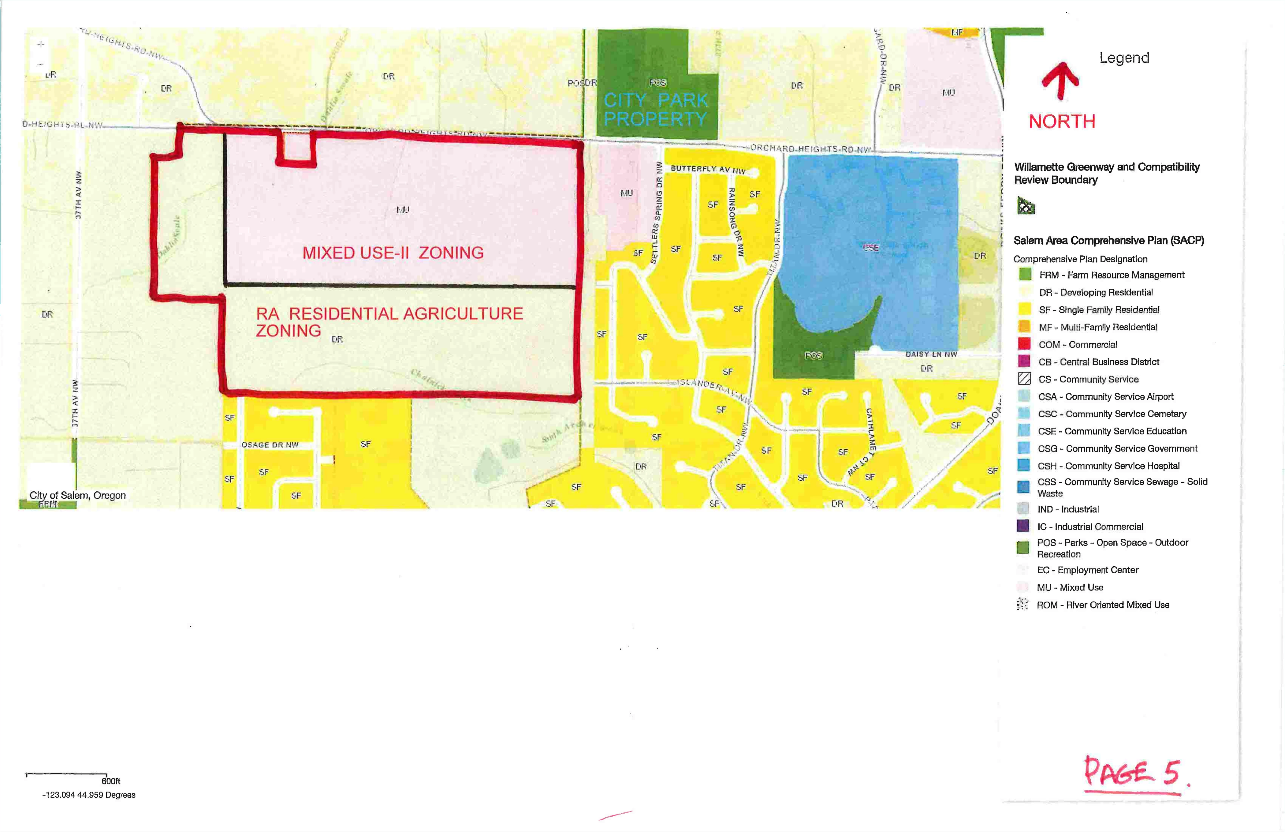
The consultant’s aerial exhibit shows substantial areas of open or cultivated land. The zoning exhibit labels the northern portion Mixed Use-II and the southern portion Residential Agriculture. The concept would reorganize mixed-use zoning and convert much of the southern land to residential development.
Commercial Zoning Would Reach Into Residential Life
The current proposed plans show 500 apartments and discuss roughly 150 more as possible—a scale that is fundamentally incompatible with this small, quiet neighborhood. Mixed-use zoning would add commercial traffic, parking, noise, lighting and late-hour activity alongside the substantial increase in residential traffic and demand. Clear limits are necessary, but mitigation doesn’t answer the larger question of whether development this substantial belongs here at all.
Box trucks, service vehicles and loading activity would add frequent commercial trips near homes. Plans should identify delivery routes, loading areas and enforceable delivery hours.
Customer, employee and resident parking would spill onto nearby streets. A complete plan should show realistic demand, on-site capacity and protections for neighborhood parking.
Loading, refuse collection, mechanical equipment, alarms and added traffic would change the area’s sound environment. Noise limits and mitigation should be defined before approval.
Parking lots, signs, storefronts and security lighting would introduce glare after dark. Residents need photometric plans, shielding standards and clear operating-hour limits.
Commercial access points and turning movements would compound residential traffic. Analysis should address queues, intersections and the full buildout—not only an early phase.
Customers, employees, deliveries and waste collection would extend activity into evenings or early mornings. Permitted hours and enforcement expectations should be public and binding.
Roads and traffic
The current proposed plans contemplate reconstruction or realignment of Orchard Heights Road, a Grice Hill Road connection, several collector routes and new internal streets. Residents need an independent traffic analysis based on the full buildout—not assumptions selected to make one phase appear manageable.
Will the traffic analysis model the full 930-home buildout, or just the 730-home figure the consultant is presenting? Peak-hour trip counts determine whether intersections fail — the baseline number matters.
How would Islander Avenue handle collector-street traffic to Titan Drive? What happens to 32nd Avenue if a new collector cuts through? And have residents on these streets been consulted?
How would residents cross collector or arterial streets, and what safe connections would be built?
Where would trucks travel, how long would road work last, and how would access be maintained?
Which improvements would be consultant-funded, and which would become City obligations?
Would road changes improve or delay fire, medical and police access?
Public land
The current proposed plans discuss a potential exchange involving City-owned property north of Orchard Heights Road near the BPA corridor. The exact values, restrictions, obligations and approval process haven’t been documented in the materials residents received.
Resident position
Publish exact parcels, acreage, ownership, easements and legal descriptions.
Release current appraisals that account for zoning, access, topography and development constraints.
Explain what the public receives—and what private development gains from the exchange.
Identify the hearings, votes, notice, review criteria and appeal rights before any commitment.
What’s verified
A consultant’s plan can show what’s being considered. It can’t substitute for accepted applications, independent studies, binding conditions or a public decision.
City records
01Our Salem zoning changes adopted in 2022
02Current zoning lookup tools
03Separate 2916 Orchard Heights decision
Consultant-prepared
01Approximately 127-acre site
02Plan 1 capacity comparison
03Plan 3 revised concept
04Plan 4 current proposal
05300-500 apartments depending on density
06320 single-family residential houses
07110 attached duplexes
08Senior housing designation
09Road and zoning concepts
10Potential land trade and small commercial center
Neighborhood record
01Resident concerns
02Approximate timing estimates
03Initial phase of approximately 50 lots
04School, water and utility discussion
Before major decisions
01Reconciled unit count
02Complete application
03Building heights and bedroom mix
04Traffic and drainage studies
05School and utility capacity
06Tree-removal inventory
07Binding open-space plan
08Land-trade parcels and appraisals
09Infrastructure cost allocation
10Formal review schedule and deadlines
The Minimum Salem Should Require
Salem should require traffic, drainage, habitat, and infrastructure studies conducted independently of the consultant and available for full public review.
Plans, unit counts, phases and land-trade terms that agree with one another.
Traffic, drainage, habitat and infrastructure studies residents can examine.
Clear criteria, binding commitments and enough time for meaningful review.
Take action
The most effective time to demand evidence and safeguards is before the proposal becomes difficult to change.
Receive concise alerts when plans, studies, notices, meetings, deadlines and decisions become available.
Join the email listRead the consultant exhibits, review Plan 4 and the earlier Plan 3, and see which questions remain unanswered.
View the source documentsAttend neighborhood meetings and future hearings. Ask specific questions and request that answers enter the record.
Get meeting alertsWhen a formal application opens, address applicable approval criteria with documented evidence—not rumors or personal attacks.
Learn how public comment worksBefore Salem advances the proposal
These are minimum requirements, not acceptance of 500 apartments or development at this scale. Residents believe the proposal is too large for this quiet neighborhood and want Salem to address that fundamental concern before it advances.
Reconcile the 500, ~650 and 898 figures before impact studies rely on them.
Publish assumptions, downstream effects, mitigations and phase-by-phase impacts.
Show how roads, water, power, sewer, schools and emergency response will keep pace.
Document wetlands, riparian corridors, wildlife habitat, significant trees and binding buffers.
Release parcel maps, appraisals, restrictions, public benefits and private development gains.
Separate usable public space from stormwater infrastructure and protect it long term.
Frequently asked questions
Sign up for email alerts so you never miss a meeting, comment deadline or plan change. Attend WSNA neighborhood meetings and any future City hearings — showing up is the single most effective thing you can do. Contact the City of Salem Planning Division at 503-588-6173 or cityplanning@cityofsalem.net to ask about the status of any applications related to this proposal. Review the source documents on this site, and send relevant information to contact@saveorchardheights.com.
Not yet — and that’s exactly why now matters. The figures on this site come from consultant exhibits, not City-approved plans. Once a formal application is filed, the window for public input narrows quickly. Acting before that happens gives residents the strongest voice.
Three hundred apartments is the consultant's headline. Five hundred is what the zoning allows. Either number would transform a quiet residential neighborhood into something unrecognizable. No traffic analysis, no utility capacity study and no emergency-response plan has shown Orchard Heights can absorb apartments at any scale. Residents oppose this development.
Yes. The consultant presents 300 apartments at 15 units per acre, but their own narrative states a maximum density of 25 units per acre — which produces 500 on the same land. Nothing in the proposal caps density at the lower figure after zoning is approved. Residents oppose apartments at either number.
It’s a consultant-created scenario showing what a more aggressive zoning arrangement could hold — 1,740 apartments, 351 lots and 56 middle-housing units. The consultant says Plan 1 isn’t the preferred plan, but residents should ask why it was created at all and what prevents a future proposal from approaching that number.
The consultant presents 730. The zoning allows 930. Plan 4 shows 320 houses, 110 duplexes and 300 apartments at 15 units per acre. At the maximum density the consultant's own narrative states, the same land holds 500 apartments — and the total reaches 930. No study has analyzed the impact at either number.
Not necessarily — but it means they could be. Mixed-use zoning permits both commercial and residential uses. The consultant’s materials mention a possible commercial center, but no plan details what it would include, how much traffic it would generate or what hours it would operate. Nearby homeowners deserve those answers before zoning is approved.
The consultant’s materials describe a possible exchange involving City-owned property north of Orchard Heights Road for land that could become a park. But no parcel maps, appraisals, ownership terms or public approval process have been documented. Residents should ask why public land is being discussed in a consultant’s proposal before the City has disclosed the terms.
Not permanently. The zoning map labels part of the site Residential Agriculture, but that’s a zoning category, not a conservation easement. If the City approves rezoning, this open land can be developed. What you see from Orchard Heights Road today — the fields, the trees, the quiet — would not survive construction at this scale.
The consultant’s revised Plan 4 now proposes keeping Orchard Heights Road at its current location and reconstructing it in place. Stantec Engineering is preparing preliminary grading plans. But reconstruction still means months or years of disruption to commutes, emergency access and school routes. Residents should demand a complete construction timeline and traffic-management plan before any work begins.
No one knows yet, and that’s the problem. The consultant’s exhibits reference tree preservation, but without a completed inventory and legally binding plan, there’s nothing stopping removal during construction. Residents should insist on an independent arborist survey before any clearing is approved.
No. Oregon’s housing laws set broad requirements for what cities must plan for, but nothing in state law mandates this exact unit count, road plan, zoning layout or land trade. The consultant may frame the project as inevitable — residents should know it isn’t. The City has discretion over scale, conditions and timing.
A separate 186-unit multifamily project was approved at 2916 Orchard Heights Road NW. The reviewed materials don’t establish a direct connection — but residents should ask whether the cumulative impact of both projects on the same road network has ever been studied together.
A formal comment period typically opens after the City receives a land-use application. The window can be short — sometimes just 14 to 21 days. Contact the City of Salem Planning Division (503-588-6173) to ask what has been filed and when comment deadlines fall. Don’t wait to be notified — sign up for alerts so you’re ready the moment the window opens.
What the Consultant Submitted to Residents
The consultant calls this proposal “Cherry Hill.” These are consultant-prepared meeting exhibits, not City-approved plans. Full-page scans preserve handwritten annotations, legends, dates and surrounding context.
Download Plan 4 ExhibitsCherry Hill Planned Development narrative dated 8-6-25. Introduces Plan 4 with 730 homes, senior housing designation, and revised road network.
Continuation of the Plan 4 narrative covering transportation, collector streets, Islander Avenue connection and street design options.
Exhibit showing existing Mixed Use-II zoning (63 acres) and Residential Agriculture zoning (64 acres) with Salem Area Comprehensive Plan designations.
Plan 4 dated 6-28-26 showing 375 lots with parks, senior housing areas, collector streets and stormwater detention.
Plan 4 with topographic survey and significant tree locations. Shows 320 SFR lots, 110 attached units, 300 apartments at 15 units/ac or 500 at 25 units/ac.
Earlier Plan 3 Rev. showing 342 single-family houses, 56 rowhouses and 500 apartments with collector street to Islander Avenue.
Topographic detail of the Orchard Heights Road and Grice Hill Road intersection area showing proposed realignment.
Plan 4 overlaid on surrounding property parcels showing collector streets, proposed MU-II zones and park locations.
Wider area map showing Alternative A (32nd Avenue collector) and Alternative B (Islander Avenue collector) connecting to Titan Drive.
Street-level map of surrounding neighborhoods with proposed and current TSP collector and arterial routes highlighted.
Google Earth satellite image showing the site boundary and surrounding West Salem neighborhoods.
Official Salem TSP map (Exhibit 5) showing street classifications including future collectors through the site.
Typical street design cross sections for minor arterial, three collector types (A, B, C) and local streets.